Dunăreni: Sacidava – ISM IV 211, discovered at Rasova; ISM IV 198; ND, Or. 39, 12; Procopius, De aedif., IV, 11 20
Location: Aliman commune, Constanța county (RAN 61032.02; CT-I-s-A-02654
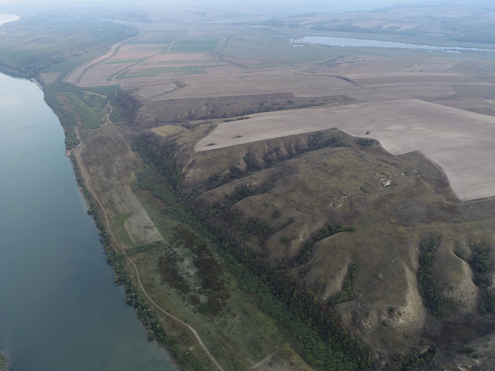
Aerial oblique photo
Complex site, located on the right bank of the Danube, on Muzait Hill, approx. 5 km northeast of Dunăreni village. Access is via DJ 223 and DC 51.
A Getae settlement, a rectangular fortlet (dimensions: 160 x 125 m), to which is added another fortification of smaller dimensions (approx. 70 x 40 m) were identified here. Roman fort (2nd – 3rd centuries AD). Late Roman and Roman-Byzantine fortification (4th -7th centuries AD). The first fortification seems to date from Trajan’s time, related to the bellum Dacicum.
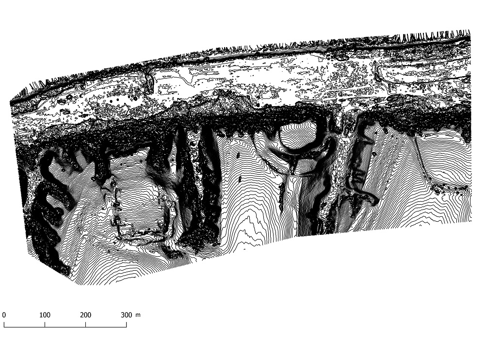
Fortifications plan
During the Principate, the auxiliary fort was occupied by cohort IV Gallorum (ISM IV 169), and after 114 by cohorts I Cilicum miliaria (ISM IV 172, 184, 202). Stamps from the legions I Italica and XI Claudia were discovered. The full plan has not yet been completed.
In the late Roman era, the fortification was rebuilt, and the stationing of a cuneus equitum scutariorum was reported here. An enclosure wall (made in opus caementicium, opus incertum, opus caementicium incertum and opus quadratum of limestone blocks), with a thickness of approx. 2 m, two gates and 7 rectangular towers were partially unveiled. In the structure of the late Roman enclosure numerous spolia, mostly funerary stelae originating from the early Roman necropolis were used. Intra muros, at different points of the perimeter of the late Roman fortification, various habitation structures have been identified, among which a large early Roman edifice, was disused during the reconstruction of the curtain wall in the 4th century AD. On the south side of the fortified area, ceramic material, oil lamps and coins, chronologically covering the entire existence of the Roman fortification from Sacidava (2nd century – beginning of the 7th century AD). 12 construction phases have been identified archaeologically, 10 of which belong to the Dominate era, including from the time of Justinian, until the first decades of the 7th century AD.
Systematic archaeological research took place between 1969 and 1982, being resumed in recent years by a MINAC collective. The most comprehensive site plan and the most pertinent archaeological interpretations were published by al. S. Ștefan more than two decades ago.
Our investigations consisted of creating a digital model of the terrain and some oblique, overview photos from which useful information can be extracted for the cadastre and for monitoring the conservation status of the site.
Ortofotoplan
DTM - Digital Terrain Model
Fortification plan with contour lines in 50cm detail.
Part of the study:
Ovidiu Țentea, Ioan C. Opriș, Florian Matei-Popescu, Alexandru Rațiu, Constantin Băjenaru, Vlad Călina, Frontiera romană din Dobrogea. O trecere în revistă și o actualizare, Cercetări Arheologice, Vol. 26, pag. 9-82, 2019, doi: https://doi.org/10.46535/ca.26.01
TIR L 35, p. 40; 63; Scorpan, C., Rezultate ale săpăturilor arheologice de la Sacidava, Pontica 10, 1977, 229-251; Zahariade, Gudea 1997, 78, nr. 36; Gudea 2005, 443-446, nr. III. 36; Nicolae 2013, p. 165; Ștefan, Al. S., Sacidava (Constantza, Roumanie), Archéologie aérienne en Roumanie, numéro spécial double de photo-interprétation, 1986, 1 et 2, Paris, 1987, 73-88; Panaite, Adriana, Miu (Bem), Carmen, Roman roads identified on aerial and satellite images within the territory of the city of Tropaeum Traiani (Moesia Inferior), Dacia, N.S. 55, 2016, 201-220 (209 fig. 1-3).