Racovița (Praetorium II ? Tabula Peutingeriana VIII, 1)
Location: Vâlcea county (RAN: 172518.01.01; VL-I-m-A-09564.01)
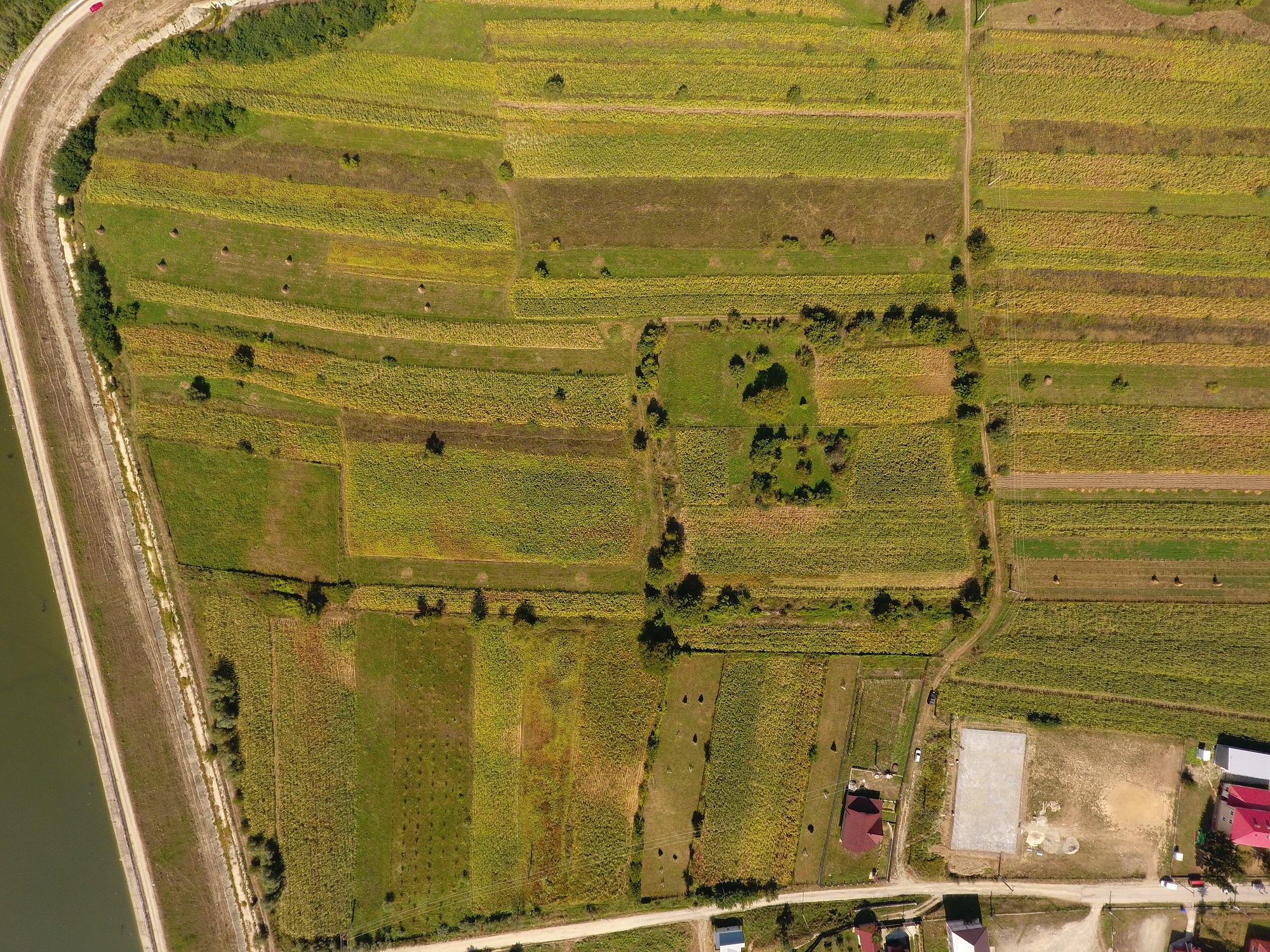
Orthophoto (September 2016)
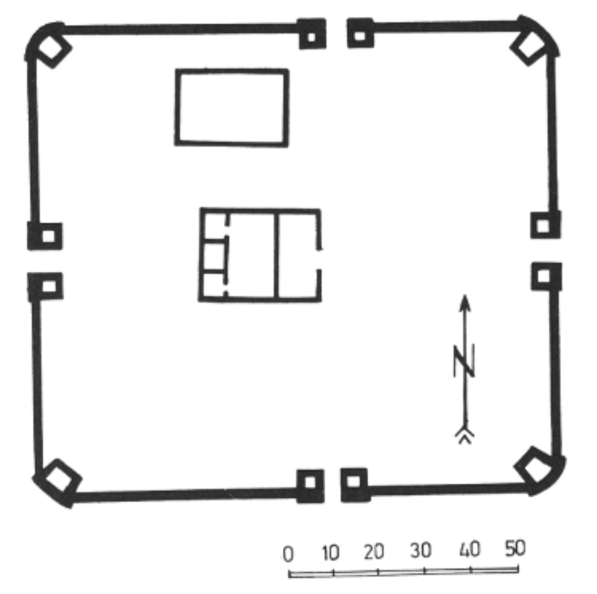
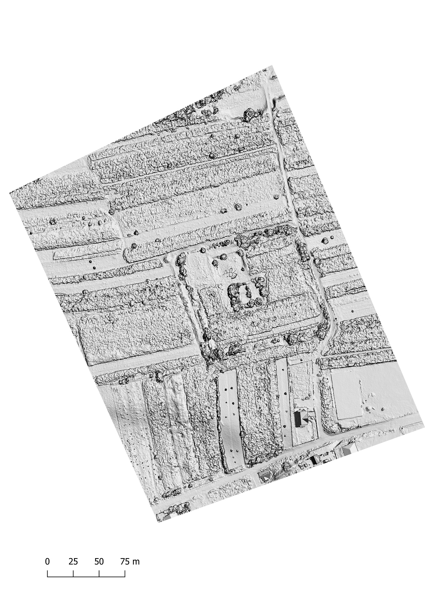
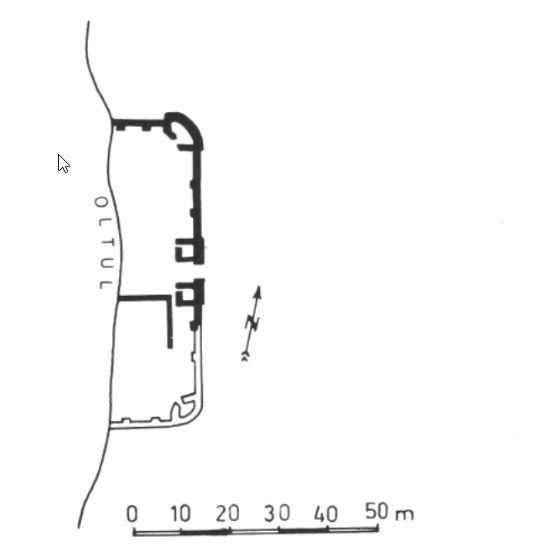
The auxiliary fort was identified on the left bank of the Olt, where Clocotici creek spills into the river, on a high plateau, at the Cetate point, located southwest of the village. It is clearly outlined on the surface of the soil in the form of a rampart of rectangular shape. Part of the masonry was preserved after the excavation was completed and is now overgrown with vegetation. Archaeological excavations were conducted by Cr. M. Vlădescu and Gh. Poenaru-Bordea in between 1976-1979. A single constructive phase, that of the stone fort, was highlighted on their basis. It is rectangular in shape, with rounded corners, dimensions are 106m x118m: the porta praetoria was located on the eastern side. Corner towers of trapezoidal shape are slightly protruding outward. The gates are equipped with quadrangular towers, in turn, slightly protruding outward. The command building was identified in the middle of the fort (principia), and on the latus dextrum, a horreum. The fort most likely dates back to Hadrian’s time, although there are some opinions that it was erected at the beginning of the 3rd century, following the abandonment of the Copăceni fortification. There are no records of the unit that was stationed here. We may be dealing with the same situation from the Copăceni fort, where several phases of construction were documented epigraphically. The situation justifies the hypothesis according to which, except for the command building, the other buildings inside the camp were built of wood and were not observed during the excavation (Bogdan-Cătăniciu 1981, 29). The civil settlement was reported in the vicinity of the fort by isolated finds of archaeological material.
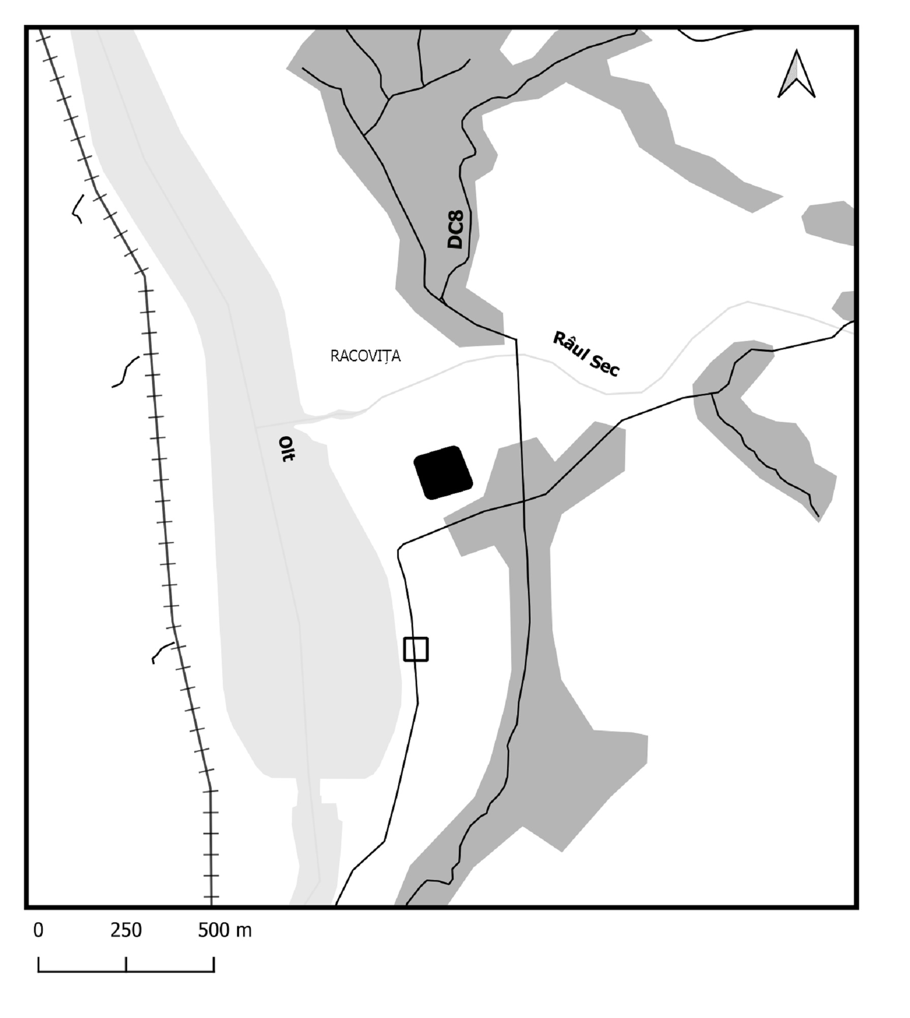
Location of the Racovița castrum (filled arrow); presumed location of the Copăceni castrum (dotted arrow)
Plan of the castrum (Tudor 1978, 289, fig. 80).
Control of access routes is done through towers or other small size military installations. Two such towers were reported. Turnul Piscului (?) is located 1.7 km northeast of the Racovița fort; respectively 4.1 km west of the Titești fort. Turnul lui Doancă is located approx. 3.5 km southeast of the Racovița camp. We do not exclude the possibility of its use in the Roman period, although the dating elements correspond to the 14th century (Vlădescu, C. M. and Poenaru-Bordea, Gh. 1981, 348). On satellite photos, a rectangular structure (approx. 45 x 40 m) can be seen 1.2 km southeast of the Racovița fort, at an altitude of 430 m, it requires further investigation in order to draw conclusions.
From the public data about the A1 motorway (Pitești-Sibiu) road infrastructure project, it appears that it will partially affect the civil settlement of the fort. Preventive archaeological research will thus be carried out in this area, which will be a good opportunity to research this objective, which is on Romania’s indicative list for inclusion in the World Heritage list.
Aerial orthophoto
Hillshade model
Plan of the castrum (Tudor 1978, 289, fig. 80) superimposed on the digital terrain model
Copăceni (Praetorium I ? Tabula Peutingeriana VIII, 1)
Location: Vâlcea county (RAN: 172554.01.01; VL-I-m-A-09525.01)
The fortification was identified north of the village, on the left bank of the Olt river, on a high terrace, at Cetate or Seliște point. The fortification was destroyed in time by the waters of the Olt river. The eastern part was investigated archaeologically between 1973-1975 by Cr. M. Vlădescu and Gh. Poenaru-Bordea. They have documented a single phase of construction. The fort was built in the opus incertum technique after a supposed square plan with a side of 64 m. The corner towers of trapezoidal shape were slightly protruding outward, similar to those of the gate on the eastern side, the only one preserved.
Plan of the castrum (Gudea 1997, 93, no. 81)
Epigraphic information indicates the construction of the fort in 138 by numerus burgariorum et veredariorum Daciae inferioris (CIL III 13795 = ILS 8909 = IDR II 587), later enlarged in140 (CIL III 13796 = ILS 8910 = IDR II 588: castra numerus burgariorum et veredariorum, quod anguste tenderet, duplicato valli pede et inpositis turribus ampliavit per Aquilam Fidum, procuratorem Augusti). It can thus be seen that what was the only archaeologically documented phase, is actually the second phase. The road along the Olt river in the Copăceni fort area was repaired in 236 AD (CIL III 1421619 = IDR II 589). The reading of an inscription on a bronze piece indicated the possible presence of some beneficiarii consularis (CIL III 13797 = IDR II 591).
Part of the study:
Ovidiu Țentea, Florian Matei-Popescu, Vlad Călina, Frontiera romană din Dacia Inferior. O trecere în revistă și o actualizare. 1., Cercetări Arheologice, Vol. 28.1, pag. 9-90, 2021, doi: https://doi.org/10.46535/ca.28.1.01
Christescu 1937, 144-147; TIR L 35, 60; Tudor 1968, 372; Tudor 1978, 288-290, nr. 32; Vlădescu, C. M. și Poenaru-Bordea, Gh. 1981. Cercetările arheologice în Castrul Roman de la Racoviţa, jud. Vîlcea şi în zona aferentă, Materiale și Cercetări Arheologice 15: 345-349; idem, Studii Vâlcene 6, 1983, 15-21; Vlădescu 1983, 108-114, nr. 19; Vlădescu 1986, 70-79; Gudea 1997, 93-94, nr. 82; Marcu 2009, 213-217, nr. 62.
Tocilescu 1900, 128-131; Wagner 1938, 204-205; TIR L 35, 35; Cr. M. Vlădescu, Gh. Poenaru-Bordea, Limes IX Mamaia, 1972, 250-252; Tudor 1978, 287-288, nr. 31; D. Tudor, SCIVA 32, 1981, 77-87; D. Tudor, Drobeta 5, 1982, 49-78; Cr. M. Vlădescu, Gh. Poenaru-Bordea, MCA Braşov, 1983, 345-349; Vlădescu 1983, 106-108, nr. 18; Vlădescu 1986, 68-70; Gudea 1997, 92-93, nr. 81; Petolescu 2002, 128-129; Marcu 2009, 204-205, nr. 48.