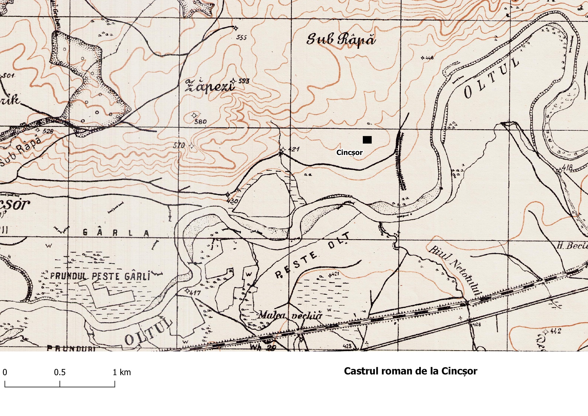
The fort is located about 4 km east from the present village, on the right bank of the Olt, at the point called Burgstadt / Grădiște. Its traces are no longer visible on the surface, which is why it was identified after numerous excavations carried out over time (excavations I. Pop 1974-1975; I. Pop, L. Petculescu-several campaigns between 1980 and 1989, D. Isac 1992). Most of it was destroyed by soil erosion. The surveys carried out over time had as their main objective the identification of the fort. Following the correlation of the information accumulated over time and the extension of a previous section, the south-western corner of this fortification could be reconstructed (fig. 3.4), arguing the existence of a wooden and earth fort, replaced by one with a stone enclosure, with a rectangular plan, with unspecified dimensions. Inside, the prints of some walls from a wooden construction could be identified.
Location of the castrum
Location of the fort on the Master Drawings
Location of the fort (Isac, Isac 1994, 103, fig. 1)
Plan of the castrum (Isac, Isac 1994, 105, fig. 2)
The encampment of the cohort II Flavia Bessorum in this fort was documented by the discovery of stamps (IDR III/4, 181; ILD 426) and an inscription on a funerary monument erected by a prefect of this troop (IDR III/4, 179). In 1986, a bronze mask, used by a rider in various processions, was discovered near the Olt river, while the river course was modified.
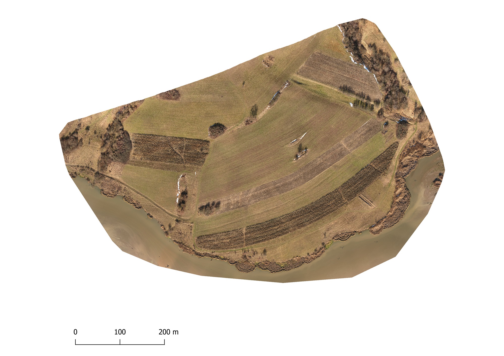
On the surface, traces of archaeological sections are distinguished, mostly covered with earth (fig. 3.5, 3.6). By correlating the cartographic Information, with those known from publications and obtained from the field in the digital model of the terrain, obtained by the acquisition of data with the drone, we were able to obtain some scenarios regarding the shape of the fort (fig. 3.7). The most likely one gives us a rectangular outline of the fortification, with sides of 130 (south) x 110 meters (west) (fig. 3.8). We aim to obtain further relevant information through geophysical prospecting in the future.
Drone orthophoto
Hillshade model
Plan reconstruction (Isac, Isac 1994, 105, fig. 2) superimposed on the digital terrain model
Parte a studiului:
Ovidiu Țentea, Florian Matei-Popescu, Vlad Călina, Frontiera romană din Dacia Inferior. O trecere în revistă și o actualizare. 1., Cercetări Arheologice, Vol. 28.1, pag. 9-90, 2021, doi: https://doi.org/10.46535/ca.28.1.01
Christescu 1937, 44, 51, 61, 183; Tudor 1968, 281; TIR L 35, 32; Vlădescu 1983, 115, nr. 23; I I. Pop, Atestări recente ale cohortei II Flavia Bessorum la Cincşor, Cumidava 13, 2, 1983: p. 43-46; Vlădescu 1986, 81; Gh. Dragotă, Masca romană de bronz de la Cincşor (jud. Braşov), SCIVA 38, 1987, 3, p. 276-280; D. lsac şi A. Isac 1994, Noi date arheologice despre castrul roman de la Cincşor (jud. Braşov), Ephmeris Napocensis 4: 103-112; Gudea 1997, 67-68, nr. 44; Gudea 2005, 497, nr. VII. B.8; Marcu 2009, 202-203, nr. 54.